Telematics

TELEMATICS is a method of monitoring an asset (car, truck, heavy equipment, or even ship) by using GPS and onboard diagnostics to record movements on a computerized map.
Technical Overview
Imagine a highly intelligent computer in your vehicle that is able to report on nearly every detail — from speed and idling, to fuel use, low tire pressure, and more. This information can mean saving on maintenance costs by better monitoring vehicles, or improving fuel efficiency by learning more about driving habits. All of this describes the universe of telematics, also known as GPS fleet tracking.
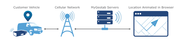
To track assets, information from the vehicle is recorded via a small telematics device — also called a black box — that plugs into the OBD II port on each vehicle. A SIM card and modem in the device enables communication on the cellular network.
There are several key components of a telematics device:
- GPS receiver
- Engine interface
- Input/output interface (expander port)
- SIM card
- Accelerometer
- Buzzer
In addition to the hardware, the algorithm used for GPS logging is another critical factor because it impacts the quality and accuracy of the data.
How Telematics Works
Data collected by the telematics device, like the GPS position and speed of the vehicle, and the g-force measured by the built-in accelerometer, are sent in an encrypted packaged format to a data center. The data then gets decoded on secure servers.
A vast amount of data can be collected via the telematics device and other connected hardware or sensors, such as position, speed, trip distance/time, idling, harsh braking and driving, seat belt, fuel consumption, vehicle faults, battery voltage, and other engine data.
In the case of Geotab, this information is stored in the cloud and brought into a fleet management software system, accessible from a desktop computer or a mobile device like a smartphone or tablet. Using the software, users are able to view and export reports and gain business intelligence such as "the top 10 drivers with the highest number of speeding incidents" or "vehicles that are due for scheduled maintenance".
For additional information regarding the use of telematics as related to a fleet, visit Geotab.com. Geotab also posts product guides, training, news and presentations on YouTube - they recommend beginning with the Geotab Essentials playlist.
The State Fleet Management team implemented the Geotab telematics system in March 2019for several purposes: (i) to help us identify areas within the fleet where Colorado we can continue to reduce its carbon footprint, (ii) to optimeze utilizing the most efficient vehicle for each use-case for which a vehicle is purchased, (iii) to support agency operations by providing relevant data to fleet coordinators. During the FY2020-21 legislative process, the Governor’s office and the Legislature approved the implementation of telematics on State Fleet Vehicles during the FY2020-21 legislative process. As of July 2025, installation rollout for devices in all applicable State Fleet vehicle is complete. Installations will continue in all newly received vehicles, and in cases where equipment malfunctions require replacement.
The cost of the Geotab Telematics ProPlus service is currently $19.75 per vehicle, which is inclusive of all installation and continued support for the device. There is no additional cost for the GO9 telematics device or installation, however Geotab is an extensible platform and equipment beyond the base device may incur additional charges for the equipment as well as for its installation. If your agency would like to purchase telematics before the planned rollout, please reach out to SFM at the shared email DPA_SFMtraining_support@state.co.us and let us know.
Geotab Access
If you already have an account, simply login to the Geotab coloradofleetmanagement_database.
If you are the Primary Fleet Coordinator for your Department and you would like to request a new account in the coloradofleetmanagement_database, please submit a ticket through our Help Desk. All other new account requests should be directed to the Primary Fleet Coordinator for your agency.
Geotab Training Specific to State Fleet Management
Please visit our Help Desk / Knowledge Base portal to review available training, documentation and webinars. The State Fleet Application Support & Training Team is working hard to create additional training materials for Geotab users which will be added to this portal as they are created. If you have suggested topic or training idea, please submit a ticket to our Help Desk. We will consider all suggestions for future training opportunities.
Commonly Used Articles (see Help Desk for additional articles)
Geotab Telematics Pre-Implementation Policy Discussion & Demo
Geotab Training and Support Opportunities
Telematics Universal Policy
Geotab New User Account
Geotab Report Distribution — PDF
Basic Functionality of Geotab Telematics — Group Administrator/Fleet Coordinator
Basic Functionality of Geotab Telematics — Group Supervisor/Vehicle Coordinator
Geotab User Information and Basic Training
Geotab Training for Commonly Performed Functions
Please note: Geotab videos sometimes feature functions that are not available to every user. To request access for specific functionality, please reach out to your agency's Primary Fleet Coordinator.
Device Installation Information
Geotab Drive App: Driver How To's
Geotab Drive App: Admin How To's
Learning to Use Geotab: Admin How To's
SFM Help Desk & Knowledge Base — Please visit the Fleet web portal to access system links such as CARS, MyCars, GEOTAB Telematics, fleet coordinator support, training opportunities, webinars, MVAC minutes, and submit help tickets as well as other fleet-related materials and information.
State Fleet Management
1001 E. 62nd Ave., A-18 | Denver, CO 80216
Toll Free: 800-723-8023 | Metro: 303-866-5222
Hours of Operation
8:00 a.m. - 5:00 p.m. | Monday - Friday